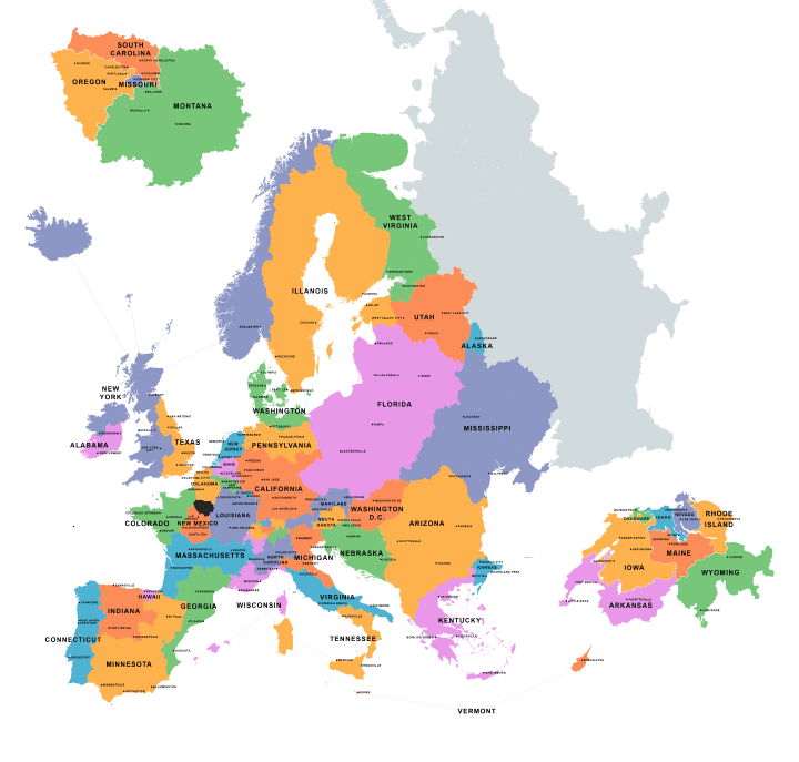
The map above shows different areas of Europe that are equal in terms of GDP to a given American state, along with cities that also correspond in terms of importance (based on population).
For example, Texas’ GDP is just over 50% of the UK’s GDP ($1.4 Trillion USD vs $2.7 Trillion USD) and the most populous city in Texas is Houston, while the most populous city in the UK is London.
Speech500 explains how he made the map:
To make this map, I calculated the GDP (nominal) of every subdivision of every European country, based on the most recent data. I then grouped these subdivisions together into areas with a GDP equal to a US state. Then, more for fun than anything else, I found the most populous/important few cities in each European area and replaced them with the names of large/important cities from the corresponding state. It took quite a while.
Overall, the economy of the EU and the United States are roughly equal at between $16-18 Trillion USD each depending on the source used. However, the distribution around Europe can lead to some interesting results.
For example, the Île-de-France (basically greater Paris and shown on the map as that weird island north of Norway) has a GDP equal to Missouri, Montana, Oregon and South Carolina combined. In terms of population though, the Île-de-France only has 12 million people whereas the 4 states combined have over 15 million people.
Similarly, Switzerland (shown off to the right on the map) has a GDP equal to Arkansas, Delaware, Idaho, Iowa, Maine, Nevada, Rhode Island and Wyoming combined. However, Switzerland has a population of just 8 million people whereas the 8 US states combined contain around 14.5 million people.
These exceptions aside, income per capita is significantly higher in the United States than Europe, with the US average around $56,000 per person compared to Europe’s $35,000 per person.
Find this map interesting? Please help us by sharing it:

David Pike says
Might be an idea to check the spelling of Illinois …
AE says
And the location of Amsterdam.. ( Newark should be at the location of Amsterdam, I presume ) The lake of IJselmeer has been colored in, while it’s in reality a big body of water.
Everything else, it’s a great map!!
Ronald says
Very interesting. I suppose the difference within Europe is much bigger then in the USA, where the Northwest European countries (Scandinavia, Benelux, UK, France, Germany, Austria, Switzerland ) will have an average that is closer to that of the US, Southern European countries below and eastern european countries far below the US average.
Have It All says
Pittsburgh=Hamburg